 Three Months Later in British Columbia…
After three months in British Columbia on his Prince of Wales Forest Leadership Award placement, David Johnes has been to the places where no roads go, seen some incredible wildlife, and most importantly cemented his forestry knowledge with diverse work experiences. In his second blog post for ICF, David describes basic tree measurement to dabbling in specialisms like timber cruising, riparian management and wildfire fighting.
“I don’t envy you guys at all” declared Brent our boat operator as he dropped us off for the start of another shift in torrential rain this morning. It’s not an ideal start to the day, yet strangely within minutes of entering the bush clambering up a steep waterlogged embankment covered in woody debris, being soaked from head to toe doesn’t actually seem that bad. Waterproof clothing may fail its primary purpose but it does retain heat. In fairness I’ve been pretty spoilt with the weather this summer, it seems more like home now.

Evening view from the Strategic floathouse
Before coming to Canada this summer I’d never seen the appeal of fishing, and as much I enjoy eating fish I’d never had the patience to catch one myself. I soon learnt that this practice is compulsory when living in coastal BC. I visited the local hardware store in Port McNeill where I explained to one of their more senior members of staff that I knew nothing about fishing and asked for advice on what to buy. He grudgingly proceeded to drag me round the store thrusting upon me a rod, line, gaff and an assortment of lures. With a lighter wallet I returned home to consult YouTube on how to set the thing up. Weeks seemed to pass at camp shift where I’d spend the evenings attempting to cast my line, losing lures and patience with nothing in return. Lee our camp operator took us out a few evenings on the boat to see if we’d have better luck, the first few trips proved fruitless but eventually I struck lucky. In three consecutive casts I caught a cod, rock fish and a salmon. Unfortunately I made the mistake of lifting the salmon straight out of the water and it jumped free. We threw the rock fish back but kept the cod and Lee cooked it along with some crabs he’d caught for tea (or “dinner” to you Canadians) the next evening.

The result of my first (and only) successful fishing trip
Basics of Forest Engineering in Coastal British Columbia
Working as part of one of Strategic’s engineering crews I have gained insight into the practices used for setting out felling boundaries and roads. The design and placement of both these features require considerations to be made for a multitude of economic, geographical, environmental and cultural constraints and sensitivities, the map below was created with the Avenza PDF maps iPad app during a site recce with Foresters Kim and Sarah.

Map from site recce with foresters Kim and Sarah.
Whilst forest blocks designated for harvesting in the UK often feature established road networks and predefined falling boundaries, existing road networks are pretty scarce in the remote forests of coastal British Columbia. Where roads are established it is common for routes to be “de-activated” once operations have concluded. De-activation involves the removal of culverts and channels which allow for the drainage of water under the road. Any activated route remains the responsibility of the licensee of the site, if culverts or channels become blocked the build-up of water can result in landslides or severe ground erosion.

Truck extracting saw logs.
Managing Site Sensitivities
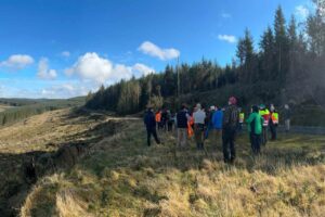
Sensitivities which need to be considered when choosing the path of falling boundaries include environmental features such as riparian management areas, protected land classifications and wildlife habitats. Cultural features also need to be protected, I had the opportunity to walk a site being engineered with an Archaeologist and a group of First Nations representatives. Their primary considerations for the site were areas of midden and culturally modified trees.
Examples of midden include heaps of shells, bones, utensils or other artefacts that have accumulated often over millennia of site occupation by Aboriginal peoples. The existence of midden sites countered the original belief that Aboriginal peoples were nomadic, serving as evidence that village sites were occupied year round. In British Columbia any midden sites are protected if they contain artefacts, features, materials or any other evidence of human habitation or use before 1846. A permit is required to alter any protected sites, to date approximately 5700 shell midden sites have been recorded in BC (Indigenous Corporate Training, 2012).

Example of a shell midden site, First Nations rep and archaeologist hiding in salal.
A culturally modified tree, commonly abbreviated to CMT is defined by the province of British Columbia as a tree as part of their traditional use of a forest. There are a large number of categories of different CMTs, the three main groups are; bark stripped trees, aboriginally logged trees and other modified trees. Each class or group is broken down into separate types, the chart shown below shows the classification used in the Province of British Columbia (Archaeology Branch, B.C. MOSBTC, 2001).

Categories of Culturally Modified Trees (Archaeology Branch, B.C. MOSBTC, 2001).
Riparian management areas (RMAs) are defined by buffer zones around water courses or areas. Watercourses are classified by size and habitat, non-fish bearing streams fit into either the S5 or S6 classifications. Streams that contain fish or are directly linked to fish bearing waters fit into one of four categories (S1 – S4, see table below). To determine classifications each stream is traversed taking measurements of width, depth and slope at regular intervals along the stretch of the watercourse. Records of substrates, intersecting features, potential fish breaks and stream junctions are also recorded. Findings recorded by engineers are only preliminary and need to be confirmed by a Biologist.
The buffer distance attached to a water course or body will depend on its classification. Some sites may use alternative systems to determine appropriate buffers. One client we worked for developed a plan for ecosystem based management with a First Nations band which specified RMA widths equal to one and half the length of dominant tree height for streams classified as S4 or S3, the dominant tree height on this site was 40 m the RMA was therefore set at 60 m – either two or three times the distance normally required (Forest Practices Code of British Columbia Act, 1995).

The buffer zones required for various site sensitivities are marked by ribbon allowing clear distinction. For some sites where sensitivities are particularly complex or expansive limitations on the areas of harvestable timber may result in operations being nonviable economically.
Basic Forestry Skills
There are a range of basic skills required for engineering operations in forestry, these involve the use of measurement and navigation tools including a compass, clinometer, string box and GPS. Compasses are used to either maintain a direction of travel or to measure a change of direction, these measurements are required when measuring distances from sensitive features to establish buffer zones or measuring changes of direction when setting out new roads, compasses are also a vital tool for navigating with paper maps.
Clinometers or laser units are used to measure angles of slope, they can also be used as part of a process for measuring vertical heights. In engineering operations clinometers are used to measure slopes of terrain and watercourses as well as part of the process used to measure heights of trees.
When measuring angles of slope it is important to remember that the measurement is being taken from eye height, to ensure an accurate reading a reference point of equal height should be used -readings are made using percentage rather than degrees. Measurements of slope are needed for road operations to ensure the road is within the client’s parameters for vehicle use. Measurements of slope taken whilst traversing watercourses can be used to determined potential breaks which might identify changes of stream classification.
When measuring tree heights an initial estimate should be made, the person measuring the tree should then stand at a distance of at least the estimated tree height away from the tree, this distance can be measured using the string box. Using the clinometer two measurements of slope are taken, one at the tree’s base and another at its very top. The difference between these two measurements should be divided by 100 and multiplied against the measured distance from the tree. If measurements are accurate the result should be equal to the tree’s height. My university lecturers Andrew Weatherall and Andrew Leslie will be pleased to know their countless field exercises have been put to good use!
A GPS unit is used to take detailed location point and line measurements. For a GPS unit to take accurate measurements it need to establish triangulated connections with at least three satellites, the GPS receiver may connect to a higher number of satellites but unless they are triangulated the unit will not be able to determine its location. Once a connection has been made the unit starts recording ‘hits’, a greater number of hits recorded usually delivers a higher level of accuracy. Weather, forest canopy density and geological features such as rock outcrops can also impact the unit’s ability to establish an adequate connection. Users can be witnessed displaying vary levels of frustration as they experiment with different positions. I spent a lot of time swearing at my unit.

Capturing traverse data with a Trimble GPS unit
Timber Cruising
Although the majority of my time has been spent working with the timber development and engineering department, I spent a few days working with a crew from the timber cruising team. The objective of timber cruising is to assess blocks of timber proposed for harvest and provide reliable and unbiased estimates of timber volume and quality per hectare. The resulting data provides a basis for calculating payment of timber sales.
Surveys conducted by timber cruisers use sample plots from predetermined locations. From each plot, trees within a certain distance from the centre point are described and measured. Information recorded from individual trees within the plot includes; diameter at breast height (DBH) – this is typically 1.3 m, tree height, tree species, timber quality – notes of scars, branching, crown height, signs of disease etc. and volume (m3). Other information can be derived from this data including; basal area (the area occupied by tree stems per hectare, expressed by m2/ha), the number of trees per hectare, gross volume (total volume estimate without deduction for defects), net volume (volume including deductions made for defects) and species breakdown.

Using an increment borer with extracted core used to estimate age.
Equipment Used
Some of the equipment shown below is the same as used in engineering operations detailed in my last blog. The equipment list explains what each item is and how it’s used.

1. Increment borer – used to extract cores from tree stems, the borer is positioned at DBH and drilled into the pith of the tree. The increments of the extracted core are then inspected and counted to determine the tree’s age.
2. Compass – used to determine direction of travel between plots.
3. Clinometer – used to measure site slope from sample plots, can also be used as part of the process for measuring tree heights if a vertex or laser is not available.
4. Prism – variable plot sampling is used where trees are tallied based on their size rather than the number or density of trees in the stand. The primary benefit of this method in place of a fixed area measurement is that it allows tree selection to be proportional to tree size. Holding the prism exactly over the plot centre the cruiser views each tree using the upper edge of the prism, looking at the tree simultaneously both through and above the prism. The image seen through the prism will be displaced horizontally. If the displacement is smaller than the DBH of the tree then the tree measurements are included within the sample. Trees are excluded when the displacement exceeds DBH.
5. Cruise vest – worn by the user to carry equipment.
6. Hand held data logger – used to record measurements taken from each plot.
7. Axe – used for blazing trees.
8. Vertex (Hypsometer) . A vertex unit measures distances by sensing sonic signals. In the field Vertex units are used by cruisers to measure tree heights and lengths, finding heights to specific sections of trees and traversing distances in between sample plots. A laser can also be used for this purpose, laser units tend to struggle measuring distances in dense vegetation. Vertex units can struggle in heavy rain where sonic signals are interrupted.
9. Notebook – for manual recording of notes.
10. Loggers tape – used to measure the distance of trees from plot centre points.
11. Topographical chain – for measuring distance when traversing between sample plots, in place of a vertex.
12. Diameter tape – used for measuring tree diameters at breast height.
Wildfire Training
During the summer of 2015 there were a total of 1,811 wildfires within BC covering a total burned area of 304,612 ha (BC Wildfire Service, 2015). Although I wasn’t trusted to take part in firefighting duties I was put on the wildfire training programmes for S100 basic fire suppression and fireline safety and S185 Fire entrapment avoidance tickets.
The S100 ticket covered the basics of the organisation required wildfire suppression, wildfire behaviour and suppression and safety procedures. I also gained practical experience using the equipment for responding to wildfires in BC.
The S185 ticket includes evaluation of various fire entrapment situations, how to exit potentially risky situations and how to deploy required resources to prevent loss of life.

Wildfire equipment, hands on training.
Going Forward
My Forest Leadership Award placement with Strategic Natural Recourse Consultants has provided me with a wide range of insights into different aspects of Forestry in BC. I’ve made some amazing friends, experienced new cultures, been to the places where no roads go, seen some amazing wildlife – more whales than I can count, not to mention the Prince of Wales.
To anyone considering applying for the award next year it’s a brilliant way to experience, compare and contrast forestry practices from alternative perspectives, hopefully just as much for those visiting the UK. I’m extremely grateful to all those who’ve been involved in making the placement possible, especially those who’ve endured working with me! Unfortunately the latter may have to have to endure me a while longer as pending a successful work permit application Strategic have offered to extend my employment.

Day off, mountain biking round Nimpkish Lake.
References
Archaeology Branch, B.C. MOSBTC (2001) Culturally Modified Trees of British Columbia, A Handbook for the Identification and Recording of Culturally Modified Trees. (Accessed at: https://www.for.gov.bc.ca/ftp/archaeology/external/!publish/web/professionals/cmthandbook.pdf Date: 29.08.15)
BC Wildfire Service (2015) Current Statistics (Accessed: http://bcwildfire.ca/hprScripts/WildfireNews/Statistics.asp Date: 15.09.15)
Forest Practices Code of British Columbia Act (1995) Riparian Management Area Guidebook (Accessed at: https://www.for.gov.bc.ca/tasb/legsregs/fpc/fpcguide/riparian/rip-toc.htm Date: 15.08.15)
Indigenous Corporate Training (2012) First Nations Middens – Some FAQs. (Accessed at: http://www.ictinc.ca/first-nation-middens Date: 28.08.15)